- Hjemmeside /
- Elektronikk /
- Elektronikk til bil og kjøretøy /
- Marine Electronics /
- Marine GPS Chartplotters /
- Weems & Plath Marine Navigation GPS Plotter
0 ratings


vare #:
25178446
Weems & Plath Marine Navigation GPS Plotter
vare #:
25178446
NOK 1031
Price Details
Excluding Shipping & Custom charges ( Shipping and custom charges will be calculated on checkout )
*All items will import from US
0 ratings
Skriv en vurdering
På lager
QTY:
Kun 6 varer igjen på lager.
Bestill nå og få den rundt Torsdag, Juli 09
Sikker transaksjon
Ubuy arbeider hardt for å beskytte din sikkerhet og personvern. Vårt avanserte betalingssikkerhetssystem sikrer konfidensialitet ved å kryptere informasjonen din under overføring ved hjelp av AES (Advanced Encryption Standards) og SSL (Secure Socket Layer)-protokoller. Betalingsopplysningene dine er 100 % sikre da vi ikke deler betalingsopplysningene dine med tredjepartsselgere.
Våre beste leveringspartnere
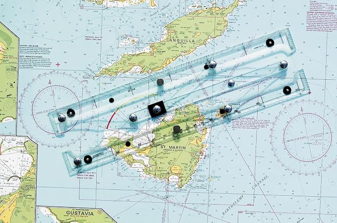
Quickly, easily, and accurately plot your GPS coordinates on a paper chart with our GPS Plotter.
Fast
Shipping
Gratis
retur*
Sikret innpakking
100 % originale produkter
PCI DSS Compliance

ISO 27001 Certified
Note: Step Down Voltage Transformer required for using electronics products of US store (110-120). Recommended power converters Kjøp nå.


Produkt detaljer
- 15-1/2 inches (39.37cm) long
- Innovative straight-line action
- Pencil guide holes
- Sturdy clear acrylic & stainless steel/brass construction
- Non-slip pads
- Protractor & parallel rule features
- Instructions on back of protective plastic sleeve
| Kompatibel med kjøretøytype | Boat |
| Ytterligere funksjoner | Effective Interface |
| Map Types | Nautical |
| Monteringstype | Panel Mount |
| Touch Screen Type | Resistive |
| Visningstype | touch screen |
| Human-Interface Input | Buttons |
| Kompatible enheter | Smartphone, Tablet |
| Kontrollmetode | Berøring |
| Are Batteries Included | No |
| Støttet satellittnavigasjonssystem | GPS |
| Sporttype | Boating |
| Merke | WEEMS-AND-PLATH |
| Modellnavn | 130 |
| UPC | 721002001849 |
| Global Trade Identifikasjonsnummer | 00721002001849 |
| Produsent | Weems & Plath |
| Modellnummer | 130 |
| Mfr Delenummer | 130 |
| Vare dimensjoner L x B x H | 15.5"L x 3"W x 0.66"H (39.4 x 7.6 x 1.7 cm) |
| Vekt av varen | 590 gram 1,3 pund |
| Kjøretøyservice type | Boat |
| Spesiell funksjon | Effective Interface |
| Karttype | Nautical |
| Produktmål (L x B x H) | 15.5"L x 3"W x 0.66"H (39.4 x 7.6 x 1.7 cm) |
PRODUKTBESKRIVELSE
Har du noen spørsmål? Chat med oss
Spørsmål og svar for kunde
-
spørsmål:
What features does the Weems & Plath Marine Navigation GPS Plotter offer?
svar: The Weems & Plath Marine Navigation GPS Plotter boasts advanced features such as precise GPS tracking, easy-to-read display options, and customizable waypoints. Designed for marine navigation, this plotter helps sailors navigate with confidence by providing clear maps and real-time positioning data. With integrated tools for route planning, users can chart their course effectively, making it a valuable asset for both recreational boaters and professional mariners. -
spørsmål:
Is the Weems & Plath Marine Navigation GPS Plotter user-friendly?
svar: Yes, the user interface of the Weems & Plath Marine Navigation GPS Plotter is designed to be intuitive and accessible even for novice users. The touch screen feature allows for easy navigation through menus and settings, which is essential when out at sea. This GPS plotter has customizable display options, making it suitable for various lighting conditions, and ensuring that all users can operate it with minimal training. -
spørsmål:
Can the Weems & Plath GPS Plotter provide real-time weather updates?
svar: The Weems & Plath Marine Navigation GPS Plotter does not inherently provide real-time weather updates; however, it can integrate with compatible devices or apps that do. The importance of weather conditions cannot be overstated in marine environments, and by connecting to weather services, users can monitor changes and make informed decisions during their voyages, enhancing safety on the water. -
spørsmål:
What types of maps does the Weems & Plath GPS Plotter support?
svar: The Weems & Plath Marine Navigation GPS Plotter supports various maritime map types, including vector charts and raster charts. This flexibility ensures users can access the most relevant and up-to-date navigational information for their specific sailing area. Many boaters prefer vector charts for their accuracy and detail, while raster charts provide historical data, catering to diverse navigational needs. -
spørsmål:
How does the Weems & Plath GPS Plotter assist in route planning?
svar: The Weems & Plath Marine Navigation GPS Plotter simplifies route planning by allowing users to set waypoints and create paths directly on its interface. The plotting software can calculate the distance and estimated travel time, enabling sailors to plan their journeys more effectively. This capability is crucial for long-distance voyages, where precise navigation can make all the difference in safety and efficiency. -
spørsmål:
What is the battery life of the Weems & Plath Marine Navigation GPS Plotter?
svar: The battery life of the Weems & Plath Marine Navigation GPS Plotter is designed to support extended use without interruption. While specifics can vary based on operational settings, users typically find the battery performs well for prolonged periods, making it suitable for day trips or longer excursions. Ensuring that the device is adequately charged before setting out is essential for continuous navigation and access to critical information while on the water. -
spørsmål:
Can I use the Weems & Plath GPS Plotter for both inland and offshore navigation?
svar: Yes, the Weems & Plath Marine Navigation GPS Plotter is versatile enough for both inland and offshore navigation. Its comprehensive mapping capabilities allow users to navigate various waterways confidently. This multifunctionality makes it ideal for recreational boaters who explore lakes and rivers as well as for those sailing in coastal environments, ensuring reliable performance in diverse settings. -
spørsmål:
Does the Weems & Plath GPS Plotter support Bluetooth connectivity?
svar: The Weems & Plath Marine Navigation GPS Plotter typically does not include Bluetooth connectivity, focusing instead on providing reliable GPS navigation without additional wireless features. Nonetheless, it can connect to external devices such as AIS transponders for better situational awareness. This ensures that every boater has the tools needed to stay informed about other vessels in the vicinity while navigating. -
spørsmål:
Are updates available for the Weems & Plath Marine Navigation GPS Plotter?
svar: Yes, users can access updates for the Weems & Plath Marine Navigation GPS Plotter to enhance functionality and support newer navigation technologies. Keeping the software up to date is crucial for ensuring optimal performance and access to the latest maritime charts. Regular updates can improve features and provide usability enhancements, making it a reliable tool for any maritime journey. -
spørsmål:
Where can I buy the Weems & Plath Marine Navigation GPS Plotter in Norway?
svar: You can purchase the Weems & Plath Marine Navigation GPS Plotter in Norway at Ubuy. Ubuy offers a reliable online platform where you can find this product and have it delivered straight to your location, ensuring easy access for all your navigation needs.
WEEMS & PLATH Marine GPS Chartplotters Editorial Review
The Weems & Plath Marine Navigation GPS Plotter offers a great concept, but falls short in terms of construction quality. The arms and hinge points that establish the parallels are flimsy and fail to maintain accurate navigation. Although it is good enough for general area navigation, it is not suitable for specific location accuracy. Some units have arrived with missing support-feet and slight twists, while others have issues with misaligned ruler markings and unreadable instructions. The responsibility for these faults lies with the manufacturer, Weems & Plath, as the quality of their packaging and the misaligned markers are a result of their Q&A department. Despite these flaws, the product functions as listed and some customers would consider buying it again.
Kundeanmeldelser og vurderinger
9 kunders vurderinger
-
5 stjerne
61%
-
4 stjerne
10%
-
3 stjerne
17%
-
2 stjerne
0%
-
1 stjerne
12%
Vurder dette produktet
Del tankene dine med andre kunder
Fordeler
- Great concept
- Functions as listed
- Arrived on time
Ulemper
- Spinkel konstruksjon
Produktets prishistorikk
Viktig informasjon
- Begrensninger: For produkter som fraktes internasjonalt, vennligst merk at eventuell produsentgaranti kanskje ikke er gjeldende; produsentens tjenestealternativer er kanskje ikke tilgjengelige; produktveiledninger, instrukser og sikkerhetsadvarsler er kanskje ikke tilgjengelig på destinasjonslandets språk; produktene (og medfølgende materiell) er kanskje ikke laget i samsvar med destinasjonslandets standarder, spesifikasjoner og krav om merking; og det kan være at produktene ikke har samme spenningsgrad og elektriske standard som destinasjonslandet eller ikke følger (det må brukes adapter eller strømomformer der dette gjelder). Mottakeren er ansvarlig for å forsikre seg om at produktet lovlig kan importeres til destinasjonslandet. Ved bestilling fra Ubuy eller deres partnere er mottakeren den registrerte importøren, og må etterleve alle lover og reguleringer i destinasjonslandet.
- Ikke alle produktene som er opplistet hos Ubuy er til salgs, siden Ubuy er en global søkemotor. Produkter er underlagt reguleringer for eksport og handel.
NOK 1031
Bestill nå og få den rundt Torsdag, Juli 09
This item is not restrict in my country.(Please click on above link if this item is not restrict in your country, So our team will review and allow.)
QTY:
Kun 6 varer igjen på lager.
Sikker transaksjon
Ubuy arbeider hardt for å beskytte din sikkerhet og personvern. Vårt avanserte betalingssikkerhetssystem sikrer konfidensialitet ved å kryptere informasjonen din under overføring ved hjelp av AES (Advanced Encryption Standards) og SSL (Secure Socket Layer)-protokoller. Betalingsopplysningene dine er 100 % sikre da vi ikke deler betalingsopplysningene dine med tredjepartsselgere.
Våre beste leveringspartnere
Rask levering over grenser
Funksjoner og fordeler
- Simplified two-step maneuver for plotting GPS coordinates.
- Compatible with any paper chart for versatile use.
- Designed for accuracy in latitude and longitude plotting.
- User-friendly interface for anyone, regardless of experience.
- Enhances traditional navigation methods with modern technology.
- Essential tool for sailors and outdoor enthusiasts.